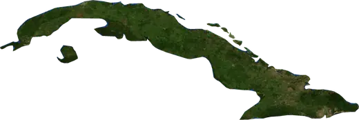
 Cuba
Cuba: earthquakes and wildfires
Latest earthquakes and active wildfires in Cuba on a live map, the strongest earthquakes and largest fires on record, and statistics by year.
Live map – Cuba
Key statistics (30 days)
Earthquakes M2.5+ and the wildfire fronts shown on the map.
Fire danger
Forecast for the area around: Havana. Danger can vary locally; follow official guidance. Source: Copernicus EMS – EFFIS (FWI).
Severe weather (forecast)
- Today: Rain – Extreme rain (≥ 50 mm) · Santa Clara
- Tomorrow: Rain – Extreme rain (≥ 50 mm) · Camagueey
Forecast for the area around: Cuba. It does not replace warnings from the national weather service. Source: ECMWF / Copernicus EMS.
Recent events in Cuba
- 3 days agoWildfire near Varadero, Cuba11 km² · 8 km SSW of Varadero, Cuba
- 75 days agoWildfire near Guantanamo, Cuba17 km² · 38 km NE of Guantanamo, Cuba
- 86 days agoWildfire near Cacocum, Cuba11 km² · 13 km SW of Cacocum, Cuba
- 109 days agoWildfire near Camagueey, Cuba11 km² · 40 km ENE of Camagueey, Cuba
- 4.9153 days agoM4.9 earthquake near Mantua, Cuba99 km WNW of Mantua, Cuba
- 4.4159 days agoM4.4 earthquake near Mantua, Cuba108 km WNW of Mantua, Cuba
Historical overview
Earthquakes M3.0+ and significant events of other hazards.
About Cuba
Cuba has recorded 179 earthquakes of magnitude 3.0 or more since 1976. The strongest was M7.0 in 1992.
Satellites have detected 8 significant wildfires here; the largest burned about 59 km².
Know the official emergency number, prepare an emergency kit and follow the instructions of your civil protection authority.
Learn more ›Earthquakes
179 earthquakes of magnitude 3.0 or more since 1976. The strongest was M7.0.
Recent earthquakes
| Mag | Location | Time (UTC) | Depth |
|---|---|---|---|
| 4.9 | 99 km WNW of Mantua, Cuba | 17.3 km | |
| 4.4 | 108 km WNW of Mantua, Cuba | 14.4 km | |
| 6.1 | 149 km WNW of Pinar del Rio, Cuba | 26.0 km | |
| 4.3 | 60 km SSW of Maisi, Cuba | 10.0 km | |
| 4.3 | 54 km SSW of Maisi, Cuba | 10.0 km | |
| 4.5 | 55 km SSW of Maisi, Cuba | 12.5 km | |
| 4.7 | 58 km SSW of Maisi, Cuba | 10.0 km | |
| 5.8 | 52 km SSW of Maisi, Cuba | 12.7 km | |
| 4.1 | 63 km SSW of Maisi, Cuba | 10.0 km | |
| 5.0 | 62 km SSW of Maisi, Cuba | 10.0 km |
Show all (11)
| Mag | Location | Time (UTC) | Depth |
|---|---|---|---|
| 5.5 | 43 km SSW of Maisi, Cuba | 10.0 km |
Strongest earthquakes on record
| Mag | Location | Time (UTC) | Depth |
|---|---|---|---|
| 7.0 | 57 km SSW of Niquero, Cuba | 23.0 km | |
| 6.8 | 31 km ESE of Pilon, Cuba | 14.0 km | |
| 6.1 | 149 km WNW of Pinar del Rio, Cuba | 26.0 km | |
| 5.9 | 54 km S of Bayamo, Cuba | 7.0 km | |
| 5.9 | 37 km ESE of Pilon, Cuba | 19.0 km | |
| 5.9 | 32 km SSE of Bartolome Maso, Cuba | 20.0 km | |
| 5.8 | 52 km SSW of Maisi, Cuba | 12.7 km | |
| 5.8 | 58 km S of Bayamo, Cuba | 11.0 km | |
| 5.6 | 54 km SSW of Guantanamo, Cuba | 14.6 km | |
| 5.6 | 32 km ENE of Moa, Cuba | 10.0 km | |
| 5.5 | 43 km SSW of Maisi, Cuba | 10.0 km | |
| 5.5 | 59 km SSW of Niquero, Cuba | 10.0 km | |
| 5.4 | 87 km SE of Maisi, Cuba | 10.0 km | |
| 5.4 | 38 km SW of Santiago de Cuba, Cuba | 13.5 km | |
| 5.3 | 50 km SSW of Maisi, Cuba | 10.0 km |
Earthquakes per year (M3.0+)
Year
| 2026 | 13 | M6.1 |
| 2024 | 11 | M6.8 |
| 2023 | 3 | M5.4 |
| 2022 | 4 | M5.0 |
| 2021 | 6 | M4.7 |
| 2020 | 8 | M5.1 |
| 2019 | 1 | M4.3 |
| 2018 | 2 | M3.8 |
| 2017 | 8 | M5.8 |
| 2016 | 14 | M5.2 |
| 2015 | 7 | M4.4 |
| 2014 | 8 | M5.0 |
| 2013 | 3 | M4.7 |
| 2012 | 1 | M4.8 |
| 2011 | 3 | M5.2 |
| 2010 | 11 | M5.6 |
| 2009 | 1 | M3.8 |
| 2008 | 4 | M4.4 |
| 2007 | 1 | M4.0 |
| 2006 | 2 | M4.3 |
| 2005 | 3 | M4.4 |
| 2004 | 2 | M4.7 |
| 2003 | 4 | M5.1 |
| 2002 | 1 | M4.3 |
| 2001 | 4 | M4.4 |
| 2000 | 2 | M4.5 |
| 1999 | 3 | M4.9 |
| 1998 | 2 | M5.6 |
| 1996 | 4 | M4.7 |
| 1995 | 2 | M4.3 |
| 1993 | 2 | M3.7 |
| 1992 | 21 | M7.0 |
| 1991 | 2 | M3.7 |
| 1990 | 4 | M5.5 |
| 1989 | 1 | M5.2 |
| 1985 | 1 | M5.1 |
| 1982 | 1 | M4.5 |
| 1981 | 1 | M4.6 |
| 1980 | 2 | M4.9 |
| 1978 | 1 | M5.1 |
| 1976 | 5 | M5.9 |
Wildfires
8 major fires since 2026. The largest covered about 59 km².
Recent fires
| Area | Location | Since | Status |
|---|---|---|---|
| 11 km² | 8 km SSW of Varadero, Cuba | Inactive | |
| 17 km² | 38 km NE of Guantanamo, Cuba | Inactive | |
| 11 km² | 13 km SW of Cacocum, Cuba | Inactive | |
| 11 km² | 40 km ENE of Camagueey, Cuba | Inactive | |
| 13 km² | 18 km NW of Remedios, Cuba | Inactive | |
| 55 km² | 15 km W of Pinar del Rio, Cuba | Inactive | |
| 59 km² | 14 km WSW of Minas de Matahambre, Cuba | Inactive | |
| 16 km² | 12 km WSW of Minas de Matahambre, Cuba | Inactive |
Largest fires on record
| Area | Location | Since | Status |
|---|---|---|---|
| 59 km² | 14 km WSW of Minas de Matahambre, Cuba | Inactive | |
| 55 km² | 15 km W of Pinar del Rio, Cuba | Inactive | |
| 17 km² | 38 km NE of Guantanamo, Cuba | Inactive | |
| 16 km² | 12 km WSW of Minas de Matahambre, Cuba | Inactive | |
| 13 km² | 18 km NW of Remedios, Cuba | Inactive | |
| 11 km² | 13 km SW of Cacocum, Cuba | Inactive | |
| 11 km² | 8 km SSW of Varadero, Cuba | Inactive | |
| 11 km² | 40 km ENE of Camagueey, Cuba | Inactive |
Regions
Places
- Havana
- Santiago de Cuba
- Holguín
- Guantanamo
- Santa Clara
- Almendares
- Diez de Octubre
- Arroyo Naranjo
- Mantilla
- Las Tunas
- Bayamo
- Boyeros
- Pinar del Rio
- Cienfuegos
- Fontanar
- Ciudad Camilo Cienfuegos
- San Miguel del Padron
- Centro Habana
- Balcon de la Lisa
- Matanzas
- Plaza de la Revolucion
- Marianao
- Cerro
- Manzanillo
- Sancti Spiritus
- Guanabacoa
- Vedado
- Palma Soriano
- Alamar
- Cardenas
- Moa
- Puerto Padre
- Contramaestre
- San Luis
- Colon
- Sagua la Grande
- Jagueey Grande
- Banes
- Bartolome Maso
- Corralillo
- Jesus Menendez
- Baracoa
- Jovellanos
- Santo Domingo
- San German
- Cacocum
- Jiguani
- Cifuentes
- Union de Reyes
- Yara
- Pilon
- Maisi
- Gibara
- Pedro Betancourt
- Cueto
- Rio Guayabal de Yateras
- Limonar
- Campechuela
- Perico
- Rio Cauto
- Aguada de Pasajeros
- Calimete
- Lajas
- Cauto Cristo
- Varadero
- Vinales
- Minas de Matahambre
- Los Palacios
- Consolacion del Sur
- Jobabo
- Camagueey